

High-Definition 360 Photography for Detailed Property Documentation
High-definition 360 photography from LNE Surveys provides a clear and accessible way to document existing property conditions. Through comprehensive panoramic imagery, project teams can examine rooms, corridors, finishes, fixtures, equipment, and other visible features without relying solely on standard photographs or repeated site visits. Images can be linked to existing floor plans or precise plans created by our team, helping users understand exactly where each view was captured within the building. Whether you are planning a renovation, reviewing a commercial property, documenting construction progress, or coordinating with remote stakeholders, our 360 photography services create a practical visual resource that can be accessed from a laptop, tablet, or compatible mobile device.
What Is High-Definition 360 Photography?
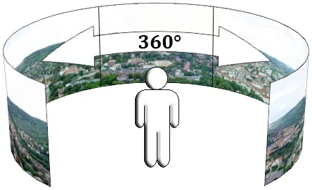
High-definition 360 photography captures a complete panoramic view from a selected position within a property. Unlike a traditional photograph, which only records the area directly in front of the camera, a 360-degree image allows users to look in multiple directions from a single capture point. The viewer can pan around the space, zoom in on visible details, and develop a more complete understanding of the surrounding conditions.
When multiple capture points are organized across a building, users can review different rooms and areas in a logical sequence. Images may also be connected to floor plans so viewers can identify where each photograph was taken. This combination of visual detail and location-based organization makes high-definition 360 photography useful for property documentation, planning, collaboration, and remote site review.
How 360 Photography Supports Existing-Conditions Documentation
Successful building projects begin with a clear understanding of what currently exists. Standard photographs may document selected walls or individual features, but they can leave important areas outside the frame. High-definition panoramic photography captures broader visual context, helping users see how visible building elements relate to one another.
The completed imagery creates a visual record of the property at the time of capture. Architects, designers, contractors, property managers, and owners can return to that record when questions arise about room layouts, finishes, equipment placement, ceiling conditions, circulation paths, or other visible details. Although 360 photography does not replace measurements, invasive inspections, or technical surveys when those services are required, it can substantially strengthen the overall building documentation package.
Linking 360 Photography to Interactive Floor Plans
One of the most valuable features of professional 360 photography is the ability to connect panoramic images to specific locations on a floor plan. Instead of searching through folders of individually named photographs, users can select an area on the drawing and open the corresponding visual view.
LNE Surveys can link 360 photography to usable floor plans supplied by the client. When reliable plans are unavailable, our team can create accurate existing-condition floor plans and place each image at its appropriate position within the building. This creates a more organized and intuitive way to navigate the property remotely.
Floor-plan-linked imagery can help users:
Locate the room or area represented in each image
Understand how individual spaces connect
Compare visual conditions with the building layout
Reference specific locations during project discussions
Share a common visual resource across multiple teams
Return to documented areas without searching through disconnected files
Our High-Definition 360 Photography Process
Every property and project has different documentation requirements. Before capturing imagery, LNE Surveys considers the size and configuration of the building, the areas that must be documented, the intended use of the final materials, and whether additional services are required.
Project Scope and Capture Planning
The process begins by identifying the spaces that need to be photographed and how the imagery will be used. A renovation team may require comprehensive interior coverage, while a property management group may need documentation of selected rooms, operational areas, or building features. Establishing the scope helps determine appropriate capture locations and the level of visual coverage required.
On-Site Panoramic Image Capture
Our team captures high-definition panoramic imagery from selected positions throughout the property. Capture points are planned to provide useful visual context and logical coverage of the identified areas. Depending on the scope, documentation may include occupied or vacant spaces, rooms under renovation, public areas, back-of-house spaces, corridors, commercial interiors, or other accessible parts of the building.
Image Organization and Floor Plan Placement
Once the photography has been captured, the images are organized according to the property layout. When floor-plan integration is part of the project, each panoramic image is linked to the location where it was taken. This allows users to move between the drawing and visual documentation more efficiently.
Quality Review and Project Delivery
The final materials are reviewed for organization, visibility, and consistency with the established scope. The completed imagery is prepared for convenient access so authorized project participants can review the property from compatible computers, tablets, and mobile devices.
What Can High-Definition 360 Photography Document?
The exact coverage depends on the project scope and visible site conditions. Panoramic photography may be used to document a wide variety of interior and exterior property features.
Rooms and Interior Layouts
Comprehensive imagery helps users understand the general arrangement of rooms, corridors, entrances, and adjacent spaces. This can be useful when evaluating circulation patterns or discussing how different areas of the building interact.
Walls, Ceilings, and Floor Finishes
High-resolution views can provide a visual reference for visible wall materials, ceiling systems, flooring, colors, and finish conditions. Users can return to the imagery during design discussions or preliminary planning instead of relying entirely on written notes.
Doors, Windows, and Architectural Features
Panoramic images may show visible door locations, window configurations, columns, stairs, millwork, built-in features, and other architectural elements. The imagery provides visual context that can complement as-built drawings.
Fixtures, Furnishings, and Equipment
When present and visible, furniture, fixtures, appliances, equipment, and operational components may be included in the visual record. This can help property teams understand how a space was being used or arranged at the time of documentation.
Construction and Renovation Conditions
Photography captured before or during construction can record visible site conditions at a specific point in the project. This creates a useful reference for progress discussions, stakeholder updates, and comparisons between different project stages.
Commercial and Operational Areas
Retail interiors, offices, hotels, warehouses, restaurants, industrial facilities, and other commercial environments may include areas that are difficult to communicate through isolated photographs. Panoramic documentation gives viewers a broader understanding of the visible space.
Benefits of Professional 360 Photography
High-definition 360 photography can improve the way project information is recorded, shared, and reviewed. Its value extends beyond simply creating an attractive panoramic image.
Review Properties Remotely
Project participants can revisit documented spaces without being physically present at the property. This is especially useful for organizations with stakeholders in different locations or teams responsible for multiple buildings.
Reduce Avoidable Return Visits
When a project participant needs to confirm a visible finish, room condition, fixture location, or other general detail, the answer may already be available within the photography. While some questions still require an on-site inspection, reliable panoramic imagery can reduce visits made only to recheck previously visible conditions.
Preserve Visual Context
Traditional photographs often focus on one feature and exclude the surrounding area. A 360-degree view allows users to look around the capture point and better understand how the photographed elements relate to the rest of the room.
Improve Communication Between Teams
Architects, contractors, owners, consultants, and property managers can refer to the same documented view during meetings and project discussions. Linking the images to floor plans makes it easier to identify the exact area being reviewed.
Create a Time-Stamped Visual Record
Photography captures how the visible property appeared at a particular stage. When documentation is performed before work begins or at scheduled project intervals, the resulting imagery can provide a useful record for future comparison.
Support Better-Informed Planning
Visual access to current conditions can help professionals prepare questions, identify areas requiring further investigation, and understand the broader property before making project decisions. The images are most effective when used alongside appropriate drawings, measurements, scans, and field assessments.
Who Uses High-Definition 360 Photography?
Professional 360 photography can support many of the people involved in owning, planning, renovating, documenting, or operating a building.
Architects and Interior Designers
Architects and designers can use panoramic imagery to become familiar with a property and revisit visible details during the early stages of planning. The photography provides added context when reviewed alongside existing-condition surveys and floor plans.
Contractors and Construction Managers
Construction teams can use 360 photography to document visible conditions before work starts or during selected stages of a project. Remote stakeholders can review the imagery to better understand site conditions and participate in project discussions.
Engineers and Consultants
Engineers and specialized consultants may use the imagery as an initial visual reference when reviewing the property. When precise dimensional or spatial information is required, the photography can be combined with professional 3D laser scanning.
Property Owners and Facility Managers
Owners and facility teams can maintain visual documentation of rooms, finishes, equipment, and operational areas. The images may be referenced when discussing maintenance, future renovations, space planning, or property transitions.
Real Estate and Development Professionals
Developers, asset managers, and real estate professionals can review the visible condition and configuration of a property from a remote location. The imagery may also help stakeholders become familiar with a building before determining whether a more detailed physical review is necessary.
Multi-Location Organizations
Businesses managing properties across several cities can use consistent 360 photography to establish an organized visual record for multiple sites. This can make collaboration easier for centralized design, construction, operations, and facilities teams.
Common Applications for 360-Degree Property Photography
The flexibility of high-definition panoramic imagery makes it useful throughout the building lifecycle.
Pre-Renovation Documentation
Capturing the space before demolition or remodeling begins creates a visual reference of existing visible conditions. Design and construction teams can review the original layout, finishes, and room configurations as the project progresses.
Construction Progress Documentation
Photography performed at selected project milestones allows stakeholders to view visible progress remotely. Images from different stages may help teams discuss changes and preserve a record of how the work developed over time.
Commercial Property Assessments
Panoramic photography can provide broad visual context during preliminary property reviews. It can help users identify areas that warrant additional investigation, field verification, measurement, or technical analysis.
Facility and Asset Documentation
Property teams can use the imagery as a visual supplement to maintenance records, floor plans, equipment information, and operational documentation. Visible assets can be viewed in the context of the room or area where they are located.
Tenant Improvement Planning
Before reconfiguring a leased commercial space, project teams can review the existing interior and share documented views with designers, contractors, and decision-makers. This supports early communication before detailed plans are finalized.
Historic Building Documentation
High-definition imagery can record visible materials, ornamentation, finishes, and architectural characteristics within older properties. For projects that require more comprehensive documentation, the photography may complement historical building documentation services.
360 Photography Versus Standard Property Photography
Standard photographs are valuable when a project requires focused images of selected features. However, they only show what was included within each individual frame. Important context may be lost when users cannot see what is beside, behind, or above the camera position.
High-definition 360 photography records the broader visible environment surrounding each capture point. Users control the viewing direction and can explore different parts of the image rather than being limited to the photographer’s original framing. This makes panoramic photography especially useful when the objective is to document and understand a space instead of showcasing only a few selected views.
The two approaches can also be used together. Standard photographs may emphasize specific components, while 360-degree images preserve the wider spatial context.
360 Photography Versus Virtual Tours
High-definition 360 photography and virtual tours are closely related, but the terms do not always describe the same deliverable.
A 360 photograph is a panoramic image captured from one position. Multiple panoramic images can be organized and linked to a floor plan so users can review different locations throughout the property. A professional virtual tour typically connects multiple viewing positions into a more immersive navigational experience that allows users to move through the property digitally.
The appropriate option depends on the intended use. Some projects primarily need organized visual documentation tied to floor plans, while others benefit from a more continuous virtual walkthrough. LNE Surveys can help determine which approach better supports the project scope.
360 Photography Versus 3D Laser Scanning
Both services capture information about an existing environment, but they serve different primary purposes.
High-definition 360 photography focuses on visual documentation. It allows users to examine visible conditions, colors, textures, finishes, fixtures, and spatial context. The imagery is valuable when project participants need an accessible visual reference.
3D laser scanning captures spatial data used to develop point clouds, measurements, models, and other technical deliverables. It is the more appropriate solution when a project requires highly detailed geometric information or precise dimensional documentation.
Depending on the assignment, the services may be combined. Panoramic photography provides visual context, while scanning supplies the spatial data needed for CAD drawings, BIM, or 3D models.
When Should 360 Photography Be Combined With Other Services?
A standalone photography package may be sufficient when the main objective is visual review. More complex architecture, engineering, construction, and property documentation projects may require additional deliverables.
As-Built Surveys
An as-built survey provides measured documentation of actual building conditions. Pairing it with 360 imagery gives project teams both drawing-based information and an accessible visual reference.
CAD Drafting
When editable two-dimensional plans are needed, CAD drafting services can transform collected building information into organized digital drawings. Linked 360 imagery can help users visually reference areas represented in those plans.
3D Scanning and Point Clouds
Laser scanning captures three-dimensional spatial data that can be processed into a point cloud. Photography may supplement that data by providing clear visual context for scanned surfaces and building areas.
BIM and Revit Modeling
Projects involving ongoing building design, coordination, or facility information may benefit from BIM deliverables. The 360 photography remains a separate visual resource that helps users understand the actual environment represented by the digital model.
Virtual Tours
When users need a more immersive way to move between documented positions, the captured panoramas may contribute to a virtual property tour.
High-Definition 360 Photography for Commercial Properties
Commercial buildings often include extensive interiors, multiple departments, specialized rooms, or areas that are difficult for every stakeholder to visit. Organized panoramic imagery helps make those spaces more accessible to people working remotely.
LNE Surveys can provide 360 photography for a range of property types, including:
Offices and corporate interiors
Retail stores and shopping environments
Hotels and hospitality properties
Restaurants and food-service spaces
Warehouses and distribution facilities
Industrial and manufacturing buildings
Healthcare and institutional properties
Educational facilities
Multifamily and mixed-use buildings
Vacant or occupied commercial spaces
Properties undergoing construction or renovation
The scope can be adapted according to the size of the property, the areas requiring documentation, and the intended project use.
Why Choose LNE Surveys for 360 Photography?
Producing useful property documentation requires more than placing a panoramic camera in the middle of a room. Capture locations must be thoughtfully planned, the images must be organized around the building layout, and the finished deliverable must be easy for project participants to navigate.
LNE Surveys specializes in documenting existing buildings for architecture, design, construction, real estate, and property-management applications. Our broader capabilities include as-built surveys, 3D scanning, CAD drafting, BIM, and virtual tours. This experience allows our team to view 360 photography as part of a larger documentation process rather than as an isolated photography service.
Each project is approached according to the property, required coverage, available drawings, and intended use of the final imagery. Clear communication and carefully organized deliverables help clients access the visual information they need without making the review process unnecessarily complicated.
Nationwide 360 Photography and Building Documentation
LNE Surveys supports building documentation projects for clients across the United States. Nationwide capabilities are especially valuable for companies managing multiple properties, construction programs, renovations, or facility portfolios across different markets.
Working with one provider can help organizations maintain a more consistent approach to photography, floor-plan integration, survey documentation, and digital project deliverables. Whether the scope includes one building or multiple locations, our team can develop a documentation strategy around the needs of the project.
Request High-Definition 360 Photography for Your Property
Give your project team a clearer way to review existing spaces from nearly anywhere. LNE Surveys provides organized high-definition 360 photography that can be connected to floor plans and combined with additional building documentation services when needed. Request a quote to discuss your property, required coverage, intended project use, and preferred deliverables.